Showing posts with label Rangamati. Show all posts

Sunday, January 9, 2022

European Standard Mahalchhari – Sindukchhari - Jalliapara Road


Last year, The Engineering Corps of the Bangladesh Army has constructed a new 15.5 km long hill road from Guimara in Khagrachhari to Mahalchhari.  Using this road, people of Rangamati, Khagrachhari and Bandarban districts will now be able to move fast across the country including Dhaka without entering Chittagong city. This will save three hours for the people of Rangamati to reach Dhaka. The path will be reduced to 68 kilometers. Mahalchhari-Sindukchhari-Jalliapara of the Ministry of Road Transport and Bridges


The road was constructed by 20 Engineer Construction Battalion under the supervision of 34 Engineers Construction Brigade of Bangladesh Army. The construction work started in February 2019 and will be completed by December 2021, but it was completed in June 2021. As a result, although not officially inaugurated, the road has been opened to public traffic.


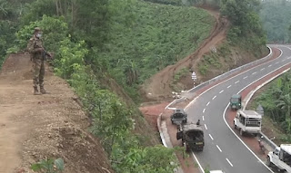
The main carpeting road is 18 feet wide. Outside, the hard solder (brick road on both sides) is about 11 feet. The road has 24 km side drain, 28 m culvert, 410 m gravity wall, 630 m retaining wall and 800 m parasiding.


Mahalchhari-Sindukchhari-Jalliapara road construction project director and 20 ECB captain Lt. Colonel Md. Amjad Hossain Didar said that the time and distance of inter-regional communication between Khagrachhari and Rangamati region will be greatly reduced through this road. The transportation and marketing of goods produced in the hilly areas will be much faster and will contribute to the expansion of the tourism industry. He said that at every stage of the construction project, emphasis is laid on carrying out development work without cutting down the hills and without harming the environment. The road will also be helpful in working on regional and internal security issues.


Major SM Khaledul Islam, project officer of the Mahalchhari-Sindukchhari-Jalliapara road construction project, said advanced engineering and technology have been utilized at every stage of the road construction. Advanced construction materials have been used. The people of the area will get the benefits.


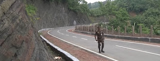
The new road has gone through the green hills. Green vegetables planted on zoom farms on both sides and farms are growing. Many local Bengalis and hill families went out to walk on the road. A young man named Chapal Chakma said that there is a road to Khagrachhari through Mahalchhari. That is very inaccessible. The people of the area are very happy because of the new road.


Thanks,


Related:

Subway Rail System in Dhaka City

LRT | Light Rail Transit Services in Narayangonj

Dhaka - Jashore in Two and Half Hoursvia Padma Bridge

Faridpur Bhanga to Mawa Rail Line

Dhaka City Metro Rail MRT Line 6 will start in 2019

Dhaka-Ishwardi- Benapole Dual GaugeRail Route

Rupsha Railway Bridge in Khulna-Mongla Rail Line

Dhaka to Kurigram Direct Express Train

Dhaka - Chattogram Double Track Railway Update

Dhaka-Mawa-Bhanga Expressway has been Inaugurated

Master Plan around Karwan Bazar 

Thursday, April 25, 2019

Special Tourist Parks in Bangladesh | SEZ


Although there are lots of possibilities, Bangladesh is far behind in the tourism industries. At present, it is very hard to pull foreign tourists at the desired level. To solve this issue, the Government has planned to set up three special tourist parks in Cox's Bazar district to promote this sector nationally and internationally. These Specialized tourism areas will attracts huge number of tourists and create new jobs opportunities. The three special tourist parks are:
  • SABRANG TOURISM PARK
  • NAF TOURISM PARK (JALIARDWIP)
  • SONADIA TOURISM PARK
Thousands of tourists in Thailand are gets crowded in just 2 kilometers long sea beach. On the other hand, the world's longest beach is the Cox's Bazar which has an unbroken length of 120 km (75 mi). But the number of tourists in the Cox's Bazar beach is comparatively little. Not just Cox's Bazar, Bangladesh has lots of attractive tourist’s spots such as Sundorbon, Mountains across the country, Kuakata sea beaches, Tea garden etc but tourism sector is still far behind in Bangladesh. The main reason is being mismanagement, environment, fail to provide international standard services etc.

To solve this issues as per plan of the Bangladesh Government with and BEZA (Bangladesh Economic Zone Authority) are working to set up three Special Tourist Zone to develop tourism sector of the country and attract foreign tourists. Of these, the Sabarang Tourism Park is being developed especially for foreign tourists with advanced and world class services. Investment here can be 3 billion US Dollars and employment facilities for at least 40 thousand people. And Naf and Sonadia Tourism Park is being built for everyone.

SABRANG TOURISM PARK:
It will be the first exclusive tourism park in Cox’s Bazar with a total land area of approximately 1027 acres. The Purest air, Sea and lagoon, Lofty hills together in Sabrang are exceptional and perfect for a special tourist’s attraction place. This place is an amazing hill and sea beach territory, multifaceted diverse and admirably beautiful with exclusive beach front.


  • Location: Sabrang is in Teknaf upazila under Cox’s Bazar district.
  • Road Connectivity: The place is five KM away from Teknaf town. Cox’s Bazar-Sabrang Marine Drive is the access road to the proposed Park which connects the National Highway (N1).
  • Air Connectivity: Cox’s Bazar Airport is only 96 KM from the Park. It takes around one and half hour drive to the Park from the Airport.
  • Port Connectivity: Teknaf Land Port is only nine KM away from this zone.
  • Nearest River: Naaf River is only eight KM from the zone.
  • Electricity: 10 MW Teknaf substation is located only seven KM away far and a new solar based power plant with a capacity of 20 MW has been proposed to build at Huyakong which is 20 km from the Sabrang Park.
  • Telecommunication: Mobile connectivity is available here. Teknaf Telephone Exchange is only eight KM away from the zone. Fiber Optic Cable connection will be done by BTCL.
  • Water Supply: Surface water is available around 3 KM areas of the zone. Four MLD water lines will be installed for drawing water from upstream of Sabrang.
  • Tourism Industries: Eco-tourism, Hotel complexes, Business tourism, Recreational tourism, Sports and extreme tourism, Water tourism, Education & Health Tourism.
  • The Sabrang Tourism Park is only half hour Sea cruise to St. Martin- a coral island.

NAF TOURISM PARK (JALIARDWIP):
Naf Tourism Park which planned to establish in total 271 acres of land will be the first island based tourism park in Bangladesh. It has scenic Beauty with a hill view on both Bangladesh and Myanmar (Burma). A cable car connection will be constructed from Ne-Taung Hill to Naf Tourism Park which will be approximately 8.5 KM long.


  • Location: The zone is located on an egg-shaped island raised in the middle of the Naaf River in Teknaf Upazilla under Cox’s Bazar district.
  • Road Connectivity: Located beside the Teknaf - Cox’s Bazar highway.
  • Air Connectivity: Only 90 KM away from the Cox’s Bazar airport.
  • Port Connectivity: The Teknaf Land Port is only 0.4 km from the proposed park.
  • Tourism attractions in Naf Tourism Park: Theme cruise for St. Martin Coral Reef Island, 5-star hotel, Restaurant, Honeymoon Park, Multi formatted Food Court & Themed Pavilions, Jungle, jogging Tracks, Night Camps, Eco-Friendly Resorts Mini Golf Course, Light & Sound Show, Entertainment zone, Infant Swimming Pool, Sky Bridge Oceanerium, Water Sports Complex, Game Parlors, Birds Watch Tower, Harbor Bridge, Cable Car Hanging, Hanging Bridge etc.

SONADIA TOURISM PARK:
The Sonadia Eco-Tourism Park location is at Sonadia Island at Maheshkhali Upazila under Cox’s Bazar district.  Total approximate land area is of this zone is 9467 acres. The land has already been adopted by BEZA on March 27, 2017 from the district administration of Cox’s Bazar. The planned tourism park in Sonadia will create a lot of FDI and employment opportunity.


  • Location: Sonadia Island is about 9 Square KM (3.5 Square Mile), offshore of the Cox’s Bazaar coast. The place is only 3 KM from Cox’s Bazar via the Maheshkhali channel.
  • Environment: The western side of the island is sandy and the northern part is green.
  • Tourism Facilities: BEZA will develop this zone as environment friendly Eco-Tourism Park, where maximum 30% of land may use as a part of truism attraction. The proposed main attractions will be Hotels & Resorts, Hanging Restaurant, Children Park, Eco-Cottage, Swimming Pool, Fun Lake, Aqua Park, Water sport, Gulf, International standard Hospital, University and Schools.
  • BEZA has already taken the initiative for feasibility study and Master Plan to set up Eco-tourism park in Sonadia Island.
  • To build eco-tourism parks in Sonadia, BEZA has initially planned to use only 30% of the space so that there is no adverse impact on the natural environment.
  • Local residents living illegally now have been cultivating fish by creating illegal ways, which are very dangerous for environment and biodiversity.
  • To build the eco-tourism park various illegal constructions in the proposed area will stop.
After the implementation of these three Special Tourism Parks, there will be a positive change in the tourism industry of Bangladesh. For information's please the official website of BEZA.

Thanks.

Related Posts:

Sunday, February 24, 2013

The Green Carpet | Srimongol Bangladesh


The place of Tea Gardens, Hills and Forests is Srimongal. Srimolgol upazila is located at the North-East side of the Baangladesh in Moulavibazar district under Sylhet Division. This place is very famous for the largest tea gardens in world like a green carpet. The Tea Research Institute in Srimongol will show you the Processing of Tea Making.


Bangladesh produces and exports a huge quantity of high quality tea every year around the globe. Most of the tea estates of the country are in Srimongol / Sreemangal / Srimangal / Sreemongal.


Little History:
Historical events Once Srimongol was a part of the Tripura State, India. The great earthquake of 1897 caused a massive change in the physio-graphic of the area. Some Archaeological heritage found in Srimongol, Nirmmai Shib Bari (1454 AD), Tamrashasan of Raja Marundanath (11th century, discovered in village Kalapur) and statue of Ananta Naraiyan (discovered during excavation in village Lamua).


Both the Tamrashasan and the statue of Ananta Narayan are now preserved in the Calcutta Museum. Marks of War of Liberation Mass killing site: BDR Camp and the WAPDA office premises; mass grave: 2 (North Varaura and South Varaura); memorial 1 (North Varaura).


Location:

  • The Geographic Latitude and Longitude of this place is at 24.3083°N 91.7333°E.
  • The area of Sreemangal Upazila (maulvi bazar district) is 450.74 sq km. It is bounded by Maulvibazar sadar upazila on the north, Tripura State (India) on the south, Kamalganj upazila on the east, Chunarughat and Bahubal upazilas on the west.
  • According to the last census, the main Town consists of 9 wards and 20 Mahallas. It has a population of 21596; male 53.33%, female 46.67%. Literacy rate among the town people is 61.6%.
  • Srimongol thana, now an upazila, was established in 1912. The upazila consists of one municipality, 12 union parishads, 124 mouzas and 206 villages.
  • The Famous Layered Tea is in this district. The name of the inventor of the layered tea is Mr. Gour.


Srimongol is the tea capital in Bangladesh. This place is also called Camellia, Green carpet or Tea Mountain. The terraced tea garden, pineapple, rubber and lemon plantations are beautiful landscapes in this area. Bilash (Gopla) River and Hail Haor are also notable.


Thanks.


Related stories:
A Human Habitation of Hilltracts and Forests
Daughter of Sea, Kuakata Beach | Bangladesh
The Longest Sea Beach in the World | Coxsbazar
The Biggest Mangrove Forest in the World | Sundarban
Famous Tea Plantation in the World | Sylhet
Famous Mainamati Lalmai and Shalvan Bihar | Comilla

Some historical and famous places in Early Dhaka

The National Web Portal of Bangladesh
Computer and IT Associations and Organizations in Bangladesh
Some important Website of Bangladesh Government
E Service | The National InfoKosh of Bangladesh 

All Districts Portals of Bangladesh
Bangladesh Tourism Sector Improvements

Thursday, February 21, 2013

A Human Habitation of Hilltracts and Forests | Rangamati


Rangamati Hill-tracts is one of the south-eastern district in Bangladesh which is very very beautiful for its natural resources. There are lots of hills in the district.  In this post I am going to tell you a little about Rangamati Hill-Tracts.


A little history about Rangamati:
Rangamati was a contesting ground for the kings of Tripura and Arakan. This region came under the Mughal Empire after the Muslim invasion in 1566. In 1737 Sher Mosta Khan, a tribal leader, took refuge with the Mughals. After this the Chakma settlement began along with various other settlements of varying ethnicity. From 1760 to 1761, this land was leased to the East India Company.

In the end of 70s the Government of Bangladesh has announced the district as one of the tourists attraction spot in the country. The total land area is near about 6500 sq. km. Some famous natural and man made attractions of Rangamati are:
  • The largest man made Lake in Asia
  • The one and only Hydro-Electricity center (Electricity generated by water power)
  • Batbunia Satellite Station
  • Karnafuli Paper mill etc.
There are about 14 (fourteen) tribes or classes of people in this district ans most of them has their own history, language and culture. There is a small museum in the city where you can see the history and culture of the people of Rangamati. There are some famous Buddhist Pilgrimages and Illustrations. The natural resources (waterfall, hills etc) are really attractable for the visitors.

The City:
Rangamati Town is mainly divided into 13 areas. Namely Vedvedi, Collegegate, Rajbari, Newmarket, Banarupa, Kathaltoli, Fishery Ghath, Reserve Bazar, Launch Ghath, Pathor Ghata, Tabalchori, Mazher Basti, Asam Basti.


Some Places of Interests:

  • Kaptai upazila under Rangamati district has Bangladesh's only hydro-electric project. The Kaptai Dam on the Karnaphuli River created for this purpose resulted in the Kaptai Lake.
  • Tourist spots include the Hanging Bridge over the Kaptai Lake, the remnants of the residence of Raja Harish Chandra Roy, archeological relics and heritage such as the Palace, Mosque and Dighi of Raja Jan Bashk Khan.
  • Cruising on the Kaptai Lake is an enjoyable way of observing the landscape as many great picnic spots, natural landmarks and historic monuments are accessible only by motorboats. The Rangamati Parjatan offers such tours to the tourists, taking them to great sights, locations of cultural and historical significance while explaining the diversity that exists in this district.
  • There are several waterfalls in the hill tracts adjoining the lake, more prominent during the monsoon because of the increased water levels due to rainfall.
  • Scattered throughout the district, are beautiful Buddhist temples and ancient relics of civilizations, all accessible by motor vehicles.
  • A stretch of road connects the tourist spots of Rangamati and Kaptai. The road goes deep into the hill tracts and displays the natural beauty and wildlife of the district.
Thanks a lot for reading this post.


Related posts:

Sunday, May 3, 2009

Daughter of Sea | Kuakata Beach | Rising and Setting of Sun | Bangladesh

On the Southampton tip of Bangladesh, a rare Tourist spot is located under Patuakhali district in Bangladesh called KUAKATA. A Fantastic tourist attraction where one can see both the Sunrise and the Sunset.


Local people named it "Sagor Konnya" (Daughter of Sea) for its natural beauty. It is famous for its wide sandy beach. The natural beauty of Kuakata is really eye catching for its wide sandy beach, natural beauty, blue sky, huge span of sea water and green forest.


The name Kuakata came from KUA (well), dig on the sea shore by the early Rakhyne Settlers in search of drinking water. They landed on Kuakata coast after expelled from Arakan by Moughals. Afterwards, it has become a tradition of digging KUA (well) in the neighborhood of Rakhaine homestead for collection of water.


Location: 
Kuakata is about 70km from the Patuakhali main city, in Latachapli union under Kalapara Police Station. Patuakhali is about 320 km from Dhaka (Capital of Bangladesh). Patuakhali District is about 30 km long and 6 km wide.

Communication to Kuakata from Dhaka by road may be some stressful, The best way is first go to Barisal by air, then from Barisal to Kuakata by road or by water is a much easier way. BRTC runs bus service from Dhaka to Kuakata via Barisal. Bangladesh Parjatan Corporation and other private tourism organization offer several guided package tours from Dhaka to Kuakata.


Attractions:
The main attraction in Kuakata is the experience of viewing the Rising and the Setting of the Crimson Sun in the Blue water of Bay of Bengal. That’s why some people think Kuakata is one of the world’s unique Beaches.


For a series of Coconut Trees, Migratory Winter Birds and Sandy Beach under blue sky Kuakata is truly a Virgin-Beach. The Beach has a gentle slope towards the Bay of Bengal. Everything here is truly natural.

Forest, Fishing, Boats plying in sea with Colorful sails, Surfing waves, Towering cliffs, and all these natural combination will blow your mind.


Kuakata is an old place for Pilgrimage of Buddhist and Hindus Community. The hundred years old Buddhist temple, The 'Rakhyne' tribal families and their Costumes and Customs indicate the Ancient Tradition and Cultural Heritage.


Two full moon Festivals – “Raash Purnima” and “Maghi Purnima” arrives here every year. People take holy bath at the bay during those festivals. A fair is also held here from where one can buy some Handicrafts and Hand-looms.

Saturday, April 18, 2009

The Biggest Mangrove Forest in the World | Sundarbans, Bangladesh

The Sundarbans mangrove forest, one of the largest such forests in the world is formed at the delta of the Ganges, Brahmaputra and Meghna rivers on the Bay of Bengal. The largest Contiguous Mangrove belt in the world is Sundarbans.

Total area of the entire Sundarbans is about one million hector, 60% of which is found in Bangladesh and the rest in India. For its Trees and Wildlife, the forest is a showpiece in the natural history of the World. Because of the dominance of saline conditions, the forest flora in the western Sundarbans is not as diverse as in the east.

Forest areas are dominated by a few species mostly Sundri and Gewu and patches of Nypa palm and several other of the 27 species of mangrove that are found in the Sundarbans. The fauna of the three sanctuaries, however, is very diverse with some 40 species of mammals, 260 species of birds and 35 species of reptiles. The flagship species is the Royal Bengal Tiger of which an estimated 350 remain in the Bangladesh Sundarbans. Other large mammals are wild boar, spotted deer, Indian otter and macaque monkey. Five species of marine turtles frequent the coastal zone and two endangered reptiles are present – the estuarine crocodile and the Indian python. Crustacea (fiddler and mud crabs) accounts for the largest portion of the animal biomass.


DATE AND HISTORY OF ESTABLISHMENT: 
All wildlife sanctuaries were established in 1977 under the Bangladesh Wildlife (Preservation) (Amendment) Act, 1974, having first been gazetted as forest reserves in 1878. The total area of wildlife sanctuaries was extended in 1996. The entire Sundarbans is reserved forest, established under the Indian Forest Act, 1878.

AREA:

Total area of Bangladesh section of Sundarbans is 595,000 ha of which 139,699 ha are protected as follows:
Sundarbans West Wildlife Sanctuary with 71,502 ha, Sundarbans East Wildlife Sanctuary with 31,226 ha and Sundarbans South Wildlife Sanctuary with 36,970 ha. Sundarbans National Park (133,010 ha), a World Heritage Site, lies to the west in India.

FOREST AREA LIMIT and GEOGRAPHICAL LOCATION:
It is located between 21”30’-22”30’N, 89”12’-90”18’E.
North Side à Khulna, Bagerhat and Sathkira districts
South Side à Bay of Bengal
East Side à Perojpur, Barisal district and Baleswar (Haringhata) river
West Side à Raimangal and Hariabhanga rivers (partially form Bangladesh boundary with West Bengal in India)


PHYSICAL FEATURES:
The Sundarbans, covering some 10,000 sq km of land and water, is part of the world’s largest delta (80,000 sq km) formed from sediments deposited by three great rivers, the Ganges, Brahmaputra and Meghna, which converge on the Bengal Basin (Seidensticker and Hai, 1983). The total area of the Bangladesh Sundarbans is 5,771 sq km (almost 62 percent of the total), of which 4,071 sq km is land and the rest water (Christensen, 1984). This area is approximately half the size of the area of mangrove that existed 200 years ago, the other half being cleared and converted to agricultural land (Hussain and Archarya 1994)


MAIN ATTRACTIONS:
Wildlife viewing, Boating inside the forest, Fishermen, Honey Collection, Wood Cutting, Nature Study, Peace and Tranquility in the wilderness, seeing the world's largest mangrove forest and the riverside beauty.


CLIMATE:
Rainfall is heavy and humidity high (80%) due to the proximity of the Bay of Bengal. About 80% of the rain fall in the monsoon, which lasts from June to October. Mean annual rainfall varies from about 1,800 mm at Khulna, north of the Sundarbans, to 2,790 mm on the coast. There is a six-month dry season during which evaporation exceeds precipitation.

Conditions are most saline in February-April, the depletion of soil moisture being coupled with reduced freshwater flow from upstream. Temperatures rise from daily minima of 2-4°C in winter to a maximum of about 43°C in March and may exceed 32°C in the monsoon. Storms are common in May and October-November and may develop into cyclones, usually accompanied by tidal waves of up to 7.5m high (Seidensticker and Hai, 1983).


FAMOUS TOURISTS SPOTS:
  • Hiron Point (Nilkamal): for tiger, deer, monkey, crocodiles, birds and natural beauty.
  • Katka: deer, tiger, crocodiles, varieties of birds and monkey, morning and evening symphony of wild fowls. Vast expanse of grassy meadows running from Katka to Kachikhali.
  • Kachikhali (Tiger Point): provide opportunities for wild tracking.
  • Tin Kona Island: tigers and deer’s.
  • Dublar Char (Island): for fishermen. It is a beautiful island where herds of spotted deer are often seen to graze.


CULTURAL HERITAGE:
There is Archaeological Evidence of earlier human occupation on the deltaic islands. The human settlements are indicative of the former presence of abundant freshwater, both from the Ganges and from non-saline ground water. Human occupation ceased in the 17th century, reportedly due to pirate attacks (Christensen, 1984).

LOCAL HUMAN POPULATION:
Approximately 2.5 million people live in small villages surrounding the Sundarbans. The area provides a livelihood at certain seasons of the year for an estimated 300,000 people, working variously as wood-cutters, fishermen, and gatherers of honey, Golpatta leaves (Nipa fruticans) and grass. Fishermen come in their boats from as far away as Chittagong and establish temporary encampments at various sites along the coast, where they remain until the approach of the monsoon season in April before returning to their homes.

SCIENTIFIC RESEARCH AND FACILITIES: 
Considerable research has been carried out on the Sundarbans ecosystem and its wildlife. Hendrichs (1975) undertook a three-month field study of tiger, concentrating on the problem of man-eating and other vertebrates and invertebrates, in 1971. Other fauna1 surveys include those of Gittins (1981) and Khan (1986) for rhesus macaque, Khan (1986) for spotted deer, Sarker and Sarker (1986) for birds, and Sarker (1985a, 1985b) and Sarker (1985) for birds of prey.


MEANS OF COMMUNICATION: 
From Khulna or Mongla Port, the only means of communication for visiting the Sundarbans is Water transport.

Transport like Motor launch, Speed Boats, Mechanized vessel might be hired for the visiting. From Dhaka visitors may travel by air, by road or by rocket steamer to Khulna (gateway of Sundarbans).


The most pleasant journey from Dhaka to Khulna is by Paddle Steamer, Rocket steamer. It presents a picturesque panorama of rural Bangladesh. Day/night long chair coach services by road are also available. The quickest way is by air from Dhaka to Jessore and then to Khulna by road.