Thursday, February 28, 2013

High Rises Buildings in Dhaka City | Pics Collection-1

Hello Viewers,
These shots has taken within the last four or five days, I took lots of shots from various places to find a better Skyline Image for the Motijheel area. All the Highrises in this post are 10+ (ten) storied or may be between ten to twenty story, only a few could be ten or within ten stories.

High-Rise buildings in Panthapath area:


High Rises in Mirpur Road and Kalabagan area:


High Rise buildings in Zigatola, SatMashjid Road, Dhanmondi area:


At present the tallest skyscraper of Dhaka city or even in Bangladesh, is in Motijheel. It is a 37 storied highrise/skyscraper. I am going to share with you some Pics of high rises above 20 storied in my next posts.

High Rises in Motijheel area:


High-Rise at Tejgaon, near Birshreshtho Jahangir gate:

 
High-Rises in Banani area:


High Rises in Gulshan-1 and Gulshan-2 area:


Thanks a lot for viewing these images, your valuable comments and suggestions will be highly appreciated.

Related posts:
Khilgaon Flyover Project Dhaka

Tuesday, February 26, 2013

Collection of Pics- 3 | Comilla City Skyline 2013


Hello Viewers / Readers,
This post is a collection of various Skyline photos of the Comilla city. All the shots were taken within the last week from different High-Rises in the city.

From the last five years the Skyline of the Comilla city is growing dramatically and within the next five to ten years the Skyline of the Comilla is going to be one of the best SKY in Bangladesh. There are more than 60 number of real estate companies including architecture / engineering / consulting / builders / construction / properties / developer etc in Comilla city. Click to view another blog report about the Changing Sky of Comilla City.

Below are some images of completed High-Rise buildings in the city. At present the highest completed Skyscraper / Building in the city is may be 15 - 16 story and construction work for lots of  20+ storied (Twenty) buildings are ongoing in the city now which will be handed over within next three to five years.

Image of some completed High-Rise Buildings in Comilla City:


Some images of the City Skyline, Comilla:


Thanks for viewing this post.

Rlated posts:
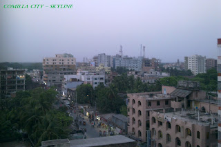
Comilla City Skyline images - 2013
Collection of Pics - 2 (Future Architecture)
High Rises in Dhaka City (Pics Collection-1)
Dhaka - Turning into a City of Glasses
World Famous Cities Skyline - Part 1
Khulna City Skyline and other Images - Part 1
Sylhet City Skyline and Highrises - Part 1
Dhaka City Skyline Images - Part 1

Dhaka City Motijheel Skyline 2013
Chittagong City Skyline Images - Part 1

Comilla City Skyline Images - Part 1
Bogra City Skyline Images - Part 1
World Famous and Beautiful City Skylines


Sunday, February 24, 2013

The Green Carpet | Srimongol Bangladesh


The place of Tea Gardens, Hills and Forests is Srimongal. Srimolgol upazila is located at the North-East side of the Baangladesh in Moulavibazar district under Sylhet Division. This place is very famous for the largest tea gardens in world like a green carpet. The Tea Research Institute in Srimongol will show you the Processing of Tea Making.


Bangladesh produces and exports a huge quantity of high quality tea every year around the globe. Most of the tea estates of the country are in Srimongol / Sreemangal / Srimangal / Sreemongal.


Little History:
Historical events Once Srimongol was a part of the Tripura State, India. The great earthquake of 1897 caused a massive change in the physio-graphic of the area. Some Archaeological heritage found in Srimongol, Nirmmai Shib Bari (1454 AD), Tamrashasan of Raja Marundanath (11th century, discovered in village Kalapur) and statue of Ananta Naraiyan (discovered during excavation in village Lamua).


Both the Tamrashasan and the statue of Ananta Narayan are now preserved in the Calcutta Museum. Marks of War of Liberation Mass killing site: BDR Camp and the WAPDA office premises; mass grave: 2 (North Varaura and South Varaura); memorial 1 (North Varaura).


Location:

  • The Geographic Latitude and Longitude of this place is at 24.3083°N 91.7333°E.
  • The area of Sreemangal Upazila (maulvi bazar district) is 450.74 sq km. It is bounded by Maulvibazar sadar upazila on the north, Tripura State (India) on the south, Kamalganj upazila on the east, Chunarughat and Bahubal upazilas on the west.
  • According to the last census, the main Town consists of 9 wards and 20 Mahallas. It has a population of 21596; male 53.33%, female 46.67%. Literacy rate among the town people is 61.6%.
  • Srimongol thana, now an upazila, was established in 1912. The upazila consists of one municipality, 12 union parishads, 124 mouzas and 206 villages.
  • The Famous Layered Tea is in this district. The name of the inventor of the layered tea is Mr. Gour.


Srimongol is the tea capital in Bangladesh. This place is also called Camellia, Green carpet or Tea Mountain. The terraced tea garden, pineapple, rubber and lemon plantations are beautiful landscapes in this area. Bilash (Gopla) River and Hail Haor are also notable.


Thanks.


Related stories:
A Human Habitation of Hilltracts and Forests
Daughter of Sea, Kuakata Beach | Bangladesh
The Longest Sea Beach in the World | Coxsbazar
The Biggest Mangrove Forest in the World | Sundarban
Famous Tea Plantation in the World | Sylhet
Famous Mainamati Lalmai and Shalvan Bihar | Comilla

Some historical and famous places in Early Dhaka

The National Web Portal of Bangladesh
Computer and IT Associations and Organizations in Bangladesh
Some important Website of Bangladesh Government
E Service | The National InfoKosh of Bangladesh 

All Districts Portals of Bangladesh
Bangladesh Tourism Sector Improvements

Thursday, February 21, 2013

A Human Habitation of Hilltracts and Forests | Rangamati


Rangamati Hill-tracts is one of the south-eastern district in Bangladesh which is very very beautiful for its natural resources. There are lots of hills in the district.  In this post I am going to tell you a little about Rangamati Hill-Tracts.


A little history about Rangamati:
Rangamati was a contesting ground for the kings of Tripura and Arakan. This region came under the Mughal Empire after the Muslim invasion in 1566. In 1737 Sher Mosta Khan, a tribal leader, took refuge with the Mughals. After this the Chakma settlement began along with various other settlements of varying ethnicity. From 1760 to 1761, this land was leased to the East India Company.

In the end of 70s the Government of Bangladesh has announced the district as one of the tourists attraction spot in the country. The total land area is near about 6500 sq. km. Some famous natural and man made attractions of Rangamati are:
  • The largest man made Lake in Asia
  • The one and only Hydro-Electricity center (Electricity generated by water power)
  • Batbunia Satellite Station
  • Karnafuli Paper mill etc.
There are about 14 (fourteen) tribes or classes of people in this district ans most of them has their own history, language and culture. There is a small museum in the city where you can see the history and culture of the people of Rangamati. There are some famous Buddhist Pilgrimages and Illustrations. The natural resources (waterfall, hills etc) are really attractable for the visitors.

The City:
Rangamati Town is mainly divided into 13 areas. Namely Vedvedi, Collegegate, Rajbari, Newmarket, Banarupa, Kathaltoli, Fishery Ghath, Reserve Bazar, Launch Ghath, Pathor Ghata, Tabalchori, Mazher Basti, Asam Basti.


Some Places of Interests:

  • Kaptai upazila under Rangamati district has Bangladesh's only hydro-electric project. The Kaptai Dam on the Karnaphuli River created for this purpose resulted in the Kaptai Lake.
  • Tourist spots include the Hanging Bridge over the Kaptai Lake, the remnants of the residence of Raja Harish Chandra Roy, archeological relics and heritage such as the Palace, Mosque and Dighi of Raja Jan Bashk Khan.
  • Cruising on the Kaptai Lake is an enjoyable way of observing the landscape as many great picnic spots, natural landmarks and historic monuments are accessible only by motorboats. The Rangamati Parjatan offers such tours to the tourists, taking them to great sights, locations of cultural and historical significance while explaining the diversity that exists in this district.
  • There are several waterfalls in the hill tracts adjoining the lake, more prominent during the monsoon because of the increased water levels due to rainfall.
  • Scattered throughout the district, are beautiful Buddhist temples and ancient relics of civilizations, all accessible by motor vehicles.
  • A stretch of road connects the tourist spots of Rangamati and Kaptai. The road goes deep into the hill tracts and displays the natural beauty and wildlife of the district.
Thanks a lot for reading this post.


Related posts: