Sunday, June 23, 2013

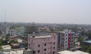
Comilla City Skyline images | 2013


The third largest / biggest Shopping Mall in Bangladesh, "Planet SR" is going to be built in Comilla City, the Comilla city is one of the fastest growing cities in the country. The Skyline of the city has changed a lot in the past few years, there are lots of construction completed highrises and lots of construction ongoing highrises in the city. Construction work of some fifteen to twenty storied highrise buildings is ongoing fast here, after the completion of the buildings the city will look different.

The Comilla region was once under the ancient Samatat and was joined with the Tripura State in India. This district came under the reign of the kings of the Harikela in the ninth century AD. Lalmai Mainamati was ruled by Deva dynasty (eighth century AD), and (during tenth and mid eleventh century AD). In 1732 it became the center of the Bengal-backed domain of Jagat Manikya.

The Peasants Movement against the king of Tripura in 1764, which originally formed under the leadership of Shamsher Gazi is a notable historical event in Comilla. It came under the rule of East India Company in 1765. This district was established as Tripura district in 1790. It was renamed Comilla in 1960. Chandpur and Brahmanbaria subdivisions of this district were transformed into districts in 1984.

All the City Skyline images of Comilla have taken on March to May 2013 from various places across the city. This is the second part of Comilla City Skyline images, take a look:


Thanks,

Related posts:


Saturday, June 22, 2013

Image Collection of Bogra City Skylines and Others | Part 1


Bogra is a city and one of the oldest cities in the northern part of Bangladesh. It is a center of commerce and trade within the Bogra District and located under the Rajshahi Division. Bogra is sometimes described as the nerve center of Northern side (North Bengal) of the country, it is also a bridge between Rajshahi and Rangpur Division.

The area of the town is approximately 71.56 km2 (27.63 sq mi), and after becoming a municipality (first ever Mayor of the municipality is Adv. Mahabubar Rahman), it consists of 21 wards (after the recent greater extension). Among many notable activities, it has been hosting cricket test matches in Shaheed Chandu Stadium.


Very close to the town there is a place called Mahasthangarh which was the earliest capital city of Bangladesh, formerly known as Pundravardhana. This place is considered to be sacred by Buddhists and Hindus alike, and is visited by tourists from all over Bangladesh throughout the year. 1971 War Hero, Sector Commander, Head of the "Z-Force", Former President of Bangladesh, Maj. Gen. Ziaur Rahman.


Source: Wikipedia
Dear Viewers/Readers,
All the images below of various places across Bogra city collected from the internet. Bogra is one of the fast growing cities in the North Bengal of the Bangladesh; take a look at the Skylines and other images of the City:


Highrise Buildings / Constructions and other images of Bogra town:

Thanks a lot.

Related posts:
Khulna City Skyline and other Images | Part 1
Sylhet City Skyline and Highrises | Part 1
Dhaka City Skyline Images | Part 1
Dhaka City Motijheel Skyline 2013 
Chittagong City Skyline Images | Part 1
Comilla City Skyline Images | Part 1
Bogra City Skyline Images | Part 1
World Famous and Beautiful City Skylines
Comilla City Skyline images | 2013
International River Port in Rajshahi beside Padma River
Rajshahi City Skyline Image | 2019
Bogra - Natore Highway Widening Project

Tuesday, June 18, 2013

Khulna City Skyline and other Images | Part 1

Khulna was a subdivision of Jessore District, was formed as the first subdivision in Bengal in 1842. The district was formed in 1882, comprising the then Khulna and Bagerhat subdivisions of Jessore district, Satkhira subdivision of 24 Parganas district (India) and the Sundarbans. Khulna was declared as a Pouroshava in 1884 and promoted to a Municipal corporation in 1984 on the platinum jubilee of Khulna Pouroshava. In 1990 Khulna has been declared as a City Corporation.

Khulna is the headquarter of Khulna District and the principal city of Khulna Division. It is located in the southern part of Bangladesh and situated on the banks of the Rupsha and Bhairab River. The River port of Khulna is one of the oldest River port in Bangladesh. Khulna is the 3rd largest city in Bangladesh. Often referred to as; Industrial City in the country. It is one of the important industrial and commercial zone of the country. It has a Sea port named Mongla on its outskirts, 38 km from Khulna City, which is the 2nd seaport in Bangladesh. Khulna is also the gateway of Sundarban (home of Royal Bengal Tiger).


The population of the city (under the jurisdiction of the City Corporation), was 1,000,000 in 2007 estimation. The wider Statistical Metropolitan Area had at the same time an estimated population of 1,435,422. The city is 333 km (by road) southwest from the capital of Bangladesh, Dhaka, or 133 km as the bird flies. To which it is connected by road, air, railway and waterways.

Viewers / Readers,
All the images have been collected from various sources on the internet. The Skyline of the 3rd largest city Khulna in Bangladesh is growing. Some high-rise constructions have already been built and some are going to be built in the near future. Take a look:


Skyline Images - Khulna City:

Highrise Buildings in Khulna City:

Other Images of Khulna:

Thanks a lot.

Related posts:
Sylhet City Skyline and Highrises | Part 1
Dhaka City Skyline Images | Part 1
Dhaka City Motijheel Skyline 2013
Chittagong City Skyline Images | Part 1
Comilla City Skyline Images | Part 1
Bogra City Skyline Images | Part 1
World Famous and Beautiful City Skylines
Comilla City Skyline images | 2013
World Famous and Beautiful City Skylines
Rupsha Railway Bridge in Khulna-Mongla Rail Route